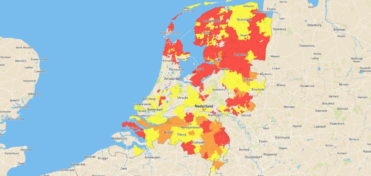
Grid operators publish map summarising transmission capacity for solar power
The regional grid operators - including Enexis, Liander and Stedin - have jointly published a map showing whether transmission capacity is still available for solar power in a given area.
This national overview helps producers who want to apply for a subsidy to produce renewable energy via the Stimulation of Sustainable Energy Production and Climate Transition (SDE++). Anyone who is going to produce renewable electricity and applies for SDE++ subsidy for this purpose is obliged to send along a transport indication. In the transport indication, the grid operator indicates whether sufficient transmission capacity is available on the electricity grid at the chosen location.
Overall view lacked
The map, which here. can be consulted, shows, for the whole of the Netherlands, where on the grid areas of the regional grid operators there is sufficient transmission capacity on the electricity grid to transmit renewable power and where there is less or no more space on the grid. The map is intended for producers planning projects that supply energy to the electricity grid via a large consumer connection, such as large solar roofs and solar parks.
Information TenneT lacks
The map allows producers to check in advance how likely it is that a transmission indication can be issued. Regionally, such maps were already available and consultable through the various regional grid operators, but a comprehensive overview was lacking until now. The information on the map is currently limited to the possibility of supplying energy to the grids of the regional grid operators. Ways to integrate the available capacity on the grids of national grid operator TenneT are under consideration.
Red does not always lead to rejection
The information on the map published now is indicative. For concrete plans, producers should always contact the relevant grid operator. In general, an application in an area that is not red will always result in obtaining a transmission indication. However, an application in a red area does not necessarily lead to a rejection of the transmission indication; consideration is always given to when the congestion is resolved and how this fits in with the project's realisation deadline. The maps are updated regularly.
Meaning of colour codes
The colour codes on the map have the following meanings:
- Transparent: no transport shortage (yet)
- Yellow: Transport scarcity looms, a modified offer regime applies
- Orange: advance notice of structural congestion to ACM
- Red: Structural congestion, new requests for transport not honoured


